
Партнерка на США и Канаду по недвижимости, выплаты в крипто
- 30% recurring commission
- Выплаты в USDT
- Вывод каждую неделю
- Комиссия до 5 лет за каждого referral
Adaptive land management as a mechanism for sustainable land use in the Nizhny Novgorod region
N. S. Kuznetsova
Nizhny Novgorod State University of Architecture and Civil Engineering Sustainable agroecosystems, bioenergetic potential of the territory
Based on the concept of a harmonious relationship of society and nature an adaptive land management orients agricultural production on using inexhaustible natural resources, self-regulation and biological adaptation of production processes (Рабочев, 2010).
A spatial and temporal flexibility of the field borders, of the schemes of crop rotation, technologies of it's cultivation, taking into account environmental factors, local conditions and market demand conditions - all that characterises the adaptive land management (Рабочев, 2010).
The result of the adaptive land management is a creation ecologically sustainable agroecosystems (Рабочев, 2010).
Traditional land management does not adequately consider the environmental balance and security of human impact on the ground, which leads to soil degradation in landscapes. At the present time the adaptive land management and land use, taking into account local conditions is not only possible but necessary.
One of the main conditions of the adaptive land management in the Nizhny Novgorod region is the consideration of the factors of erosion. 6604 km2 of agricultural land of the Nizhny Novgorod region are under the influence of the water erosion; it is 24,3% of the total area. Erosion processes are the most widespread in the area of the right bank of Volga by reason of the natural conditions and as a consequence of economic activities. Water erosion is causing by such environmental conditions as dissected topography, low forest cover area, loamy and clayey texture of the soil, lack of structure in the upper layer as a result of economic activity.
The model of strategy of adaptive intensification of agriculture involves (Рабочев, 2010):
- design the adaptive agricultural landscapes and agrosystems;
- evaluation of the natural resource potential of the territory;
- design the environmentally sustainable agroecosystems;
- evaluation of the environmental organization of the territory.
And, as a perspective, the resource-environmental evaluation of land management activities on the basis of bioenergy.
Kstovo region has been chosen as the object of the research as an area with a complicated relief, whose territory is largely exposed to water erosion. The method of adaptive land management was applied in agricultural enterprise "Zaprudnovskoe" in Kstovo region. The aim of the research was the territorial organization of the enterprise in the adaptive land management.
The study of methods of the adaptive land management and the research of capabilities of its application to the selected area led to the tasks of the work:
a) study the methods of the adaptive land management;
b) collection and analysis the materials;
c) conducting ecological and landscaping zoning in the study area;
d) development of the scheme of territorial organization of the study area;
e) evaluation of the effectiveness of land management activities on the basis of bioenergy.
In the course of research there was used a number of methods of scientific knowledge: description, analysis, synthesis, generalization and modeling.
The research was conducted on the basis of the following materials:
1. Statistical reports of the State Land Cadastre. A report on the availability and distribution of Kstovo region's land in .
2. Report on the availability, condition and use of land of Nizhny Novgorod region in 2008.
3. The plan of CJSC "Zaprudnovskoe" on a scale 1:10000.
4. The soil map of CJSC "Zaprudnovskoe" on a scale 1:10000.
5. The soil of "Zaprudnovsky" in Kstovo region and recommendations for their use and improve.
6. The system of agriculture and land management of "Zaprudnovsky" in Kstovo region.
Data from other sources were also involved in the research.
Natural resource potential of the study area was evaluated on the basis of these data: there was made the analysis of soil and topography.
Analyzing the soil of the study area there was allocated four agroecological groups of lands: plakor, moderately erosional, strongly erosional and floodplain land. The lands of these groups differ in humidity and degree of development of the erosion. In the basis of this classification there were laid such indicators as the thickness of humus horizon, physico-chemical properties and degree of erosion. The indicator of erosion of sloping lands in the study area amounted 0,918.
For evaluation the relief there were calculated:
1) index of the evenness of terrain, amounted 0,909.
2) generalized index of the quality of the relief, amounted 0,914.
The closer the value of this index to unity, the lower amenability of soils to washout.
The data obtained formed the basis of the construction of environmentally sustainable agroecosystems. Herewith there was formed the map of ecological and landscaping zoning, which represent the areals corresponding to the agroecological requirements of certain crops (Fig. 1). For this purpose arable lands were distributed to 3 categories.
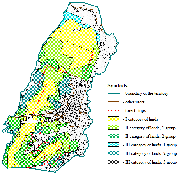
Fig. 1 – The map of ecological and landscaping zoning and a system of forest strips, the scale of 1:40000
I category of lands is plakor soils on flat land. They are suitable for the cultivation of all crops without any restrictions.
II category of lands includes two groups. They are suitable for the cultivation of field crops with a part of row crops, but with some restrictions. Organization of erosion control activities is obligatory for the land of the second group.
III category of lands is divided into 3 groups requiring technical, agroforestry and hydrotechnical activities.
The projecting environmentally sustainable agroecosystems, especially in areas with a complicated relief and high proportion of eroded soils, is impossible without the practice of agroforestry to protect the soil from the erosion.
In order to reduce the soil erosion and to create the environmentally favorable situation, there was made a system of forest strips, which became an ecological carcass of the territory (Fig. 1). According to the calculations it protects 28.2% of arable land. A complete ecological balance is achieved by taking into account an agroecological disposition of crops in this area, particularly cereals and perennial grasses.
The fixity of ecological stability of the territory decreases with a growth of agricultural development, of intensive use of land and development of the territory. To evaluate the impact of factors negative for the environment there was calculated the coefficient of ecological stability. For this area, this coefficient is 0.28, which means that the area is environmentally unstable.
The coefficient of anthropogenic load before the design is 3,70, after the design – 3,68, which means that it has not changed.
However, the technique of adaptive land management also presupposes a transformation of the natural landscape in agricultural landscapes with other modes and properties and it is based on the optimization of the structure of agricultural land with an utilization of a bioenergy potential of the territory. The direct link between the existing areas of environmentally stabilizing ecosystems (forest strips, forage lands) and the areas with ecologically destabilizing agroecosystems (arable land) is taking into account. The bioenergetic potential of the territory has to be computed for this.
At present time there is no sufficient data to calculate the bioenergetic potential of the study territory and consequently, to optimize the structure of agricultural land. Therefore, this work has its continuation in the study of this direction of adaptive land management and its application on this territory.
BIBLIOGRAPHY
1. Рабочев, Г. И. Экологическая эффективность адаптивного землеустройства : учеб. пособие / Под ред. ; Самар. гос. с.-х. акад. – Самара : СГСХА, 20с.
2. Доклад о состоянии и использовании земель сельскохозяйственного назначения / М-во с.-х. Рос. Федерации. – М. : Росинформагротех, 20с.
3. Статистические отчеты Государственного Земельного кадастра. Отчет о наличии и распределении земли Кстовского района за гг. / Межрайон. территор. отд. Кстовского р-на упр. Роснедвижимостью по Нижегор. обл. – Н. Новгород, 2010.
4. Доклад о наличии, состоянии и использовании земель Нижегородской области в 2008 г. / Федер. служба земел. кадастра России. Ком. по земел. ресурсам и землеустройству по Нижегор. обл. - Н. Новгород : [б. и.], 20с.
5. Почвы совхоза "Запрудновский" Кстовского района Горьковской области и рекомендации по их использованию и улучшению / Волго-Вят. гос. проект. ин-т по землеустройству "Волговятгипрозем". – Горький : [б. и.], 1983.
6. Система земледелия и землеустройства совхоза «Запрудновское» Кстовского района Горьковской области / Волго-Вятский гос. проект. ин-т по землеустройству "Волговятгипрозем". – Горький : [б. и.], 1984.
