

Партнерка на США и Канаду по недвижимости, выплаты в крипто
- 30% recurring commission
- Выплаты в USDT
- Вывод каждую неделю
- Комиссия до 5 лет за каждого referral
UDC 004.67
RESTORATION OF MISSING DATA IN
TIME-SERIES OF LANDSAT-8 AND SICH-2 SATELLITE IMAGES USING SELF-ORGANIZING KOHONEN MAPS
Sergii Skakun, phd, docent;
Ruslan Basarab, assistant;
Department of Computer Sciences,
National University of Life and Environmental Sciences of Ukraine, Kyiv, Ukraine
Optical remote sensing images from space are essential source of information for solving a wide range of applications. Those include environmental monitoring [1], disaster management and risk assessment [2], agriculture mapping [3], to name a few. In many cases, a time-series of satellite images is used to discriminate or estimate particular land parameters. One of the factors that influence the efficiency of optical satellite imagery is the presence of clouds. This leads to the occurrence of missing data that need to be addressed.
In this work we propose to use self-organizing Kohonen maps (SOMs) for missing data restoration in time-series of high and medium spatial resolution satellite imagery. The approach takes advantage of SOMs to dealing with missing values by encoding samples with non-missing values during a training phase, and then reconstructing missing values from SOM weights. Efficiency of using SOMs is qualitatively assessed [4] for Landsat-8 (30 m spatial resolution) and Sich-2 (8 m spatial resolution) data. Minimal error of restoration was 11% for Landsat-8 and 4% for Sich-2 (example of Sich-2 data restoration is presented on Pic. 1).
In general, quality of restoration Sich-2 images was better than for Landsat-8 which can be explained by higher radiometric resolution of Landsat-8. The approach is found to be more effective for restoration areas with vegetation than artificial surfaces. Also, increasing the number of training samples does not lead to improving quality of restoration. Therefore, a subset can be used to effectively train SOM for restoring missing values. It is found that increasing the number of training samples for training SOMs does not lead to considerable increase of quality of restoration.
The proposed approach has the following advantages: no need of ancillary data; it can be automatically implemented for processing large amounts of images; robustness (can be applied for different remote sensing instruments).
Ongoing are activities on assessing the proposed methodology for remote sensing applications, in particular land cover and crop mapping.
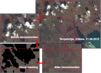
Picture 1. Example of restoration missing values on a Sich-2 image acquired on 1 August 2013.
Literature
1. Kravchenko A. N. Water resource quality monitoring using heterogeneous data and high-performance computations / A. N. Kravchenko, N. N. Kussul, E. A. Lupian, V. P. Savorsky, L. Hluchy and A. Yu. Shelestov // Cybernetics and Systems Analysis. – 2008. – Vol. 44, No. 4. - P. 616-624.
2. Skakun S. Flood Hazard and Flood Risk Assessment Using a Time Series of Satellite Images: A Case Study in Namibia / S. Skakun, N. Kussul, A. Shelestov, and O. Kussul // Risk Analysis. – 2013. doi:10.1111/risa.12156.
3. Gallego F. J. Efficiency assessment of using satellite data for crop area estimation in Ukraine / F. J. Gallego, N. Kussul, S. Skakun, O. Kravchenko, A. Shelestov, and O. Kussul // International Journal of Applied Earth Observation and Geoinformation – 2014. No. 29. – P. 22–30.
4. Skakun S. V. Reconstruction of missing data in time-series of optical satellite images using self-organizing Kohonen maps (SOMs) / S. V. Skakun, R. M. Basarab // Problemy Upravleniya I Informatiki – 2014. No. 6. P. 88 – 94.
