

Партнерка на США и Канаду по недвижимости, выплаты в крипто
- 30% recurring commission
- Выплаты в USDT
- Вывод каждую неделю
- Комиссия до 5 лет за каждого referral
 Management processes with registration of consumers and water and sewage networks in Brazil with the use of free software TerraLib - GIS
Jose Maria Pinheiro Villac
Author (s) Affiliation: NEXUS Geoengenharia
Mailing Address: Rod Pres. Dutra, km 137.8 Room 109 – Parque Tecnológico - São José dos Campos - SP - Zip 12247-004
E-mail Address: *****@***com
Telephone number (s):5512-32017100
Fax number (s): 5512-32017100
Author (s) and a brief Photograph Bio data:
Electrical Engineer from the School of Engineering Sao Carlos – Specialization in Computer Graphics at California Institute of Technology.
Abstract
This paper presents experience with development and implementation of a Geographic Information System – GIS, using free software Terralib by storing information from commercial register associated with water and sewage network a toll to support management of processes and reduce waste.
It presents the implementation in two states and two local operators, integration with commercial register and consumer and network interface with telemetry system and simulation software Epanet in one.
It shows how a GIS comes along to support company processes, integrated and disseminated among the departments of maintenance, design and commercial operation.
Keywords
Registration of water networks and sewage consumers, Geographic Information System, TerraLib.
INTRODUction
The management of losses in an operator sanitation will necessarily register of water networks and consumers which allowed the realization of the hydraulic simulation of water networks.
A contract signed through the Programa das Nações Unidas para o Desenvolvimento – PNUD a technical cooperation agreement with Unidade de gerenciamento do programa de modernização do setor saneamento – UGP/PMSS from Ministry of Cities, the following products were developed in geographic information for sanitation sector.
· Research and evaluation of IT solutions to the market and specialized institutions, design and analysis solutions for GIS applicable to management infrastructure and basic sanitation services, development technical specifications, terms of reference (TR)
· Coordination and integration of technical staff to perform activities of
supervision and monitoring the project implementation, including those relating to: model design, organization, implementation and public operation system
for ongoing management of their software.
OBJECTIVE
This paper presents the necessary specifications for a network and consumer software focused in combat water loss, using free software Terralib, developed by National Institute for Space Research - INPE, based on the recommendations obtained from the companies that it was implemented in the form of special design.
RESULTS
The main result we found that even in sanitation operators who had resources for the implementation of a GIS solution, these have been implemented only in main cities, leaving a difficulty in providing resources for an acquisition of technologies for smaller cities. We also observed that the component of the implementation process generally requires the same investment that carried with the licenses acquisition, often requiring a larger investment because cartographic database doesn’t exist or network information and existing customers.
TECHNOLOGY
Were verified open source technologies on the market, and TerraLib technology was chosen, developed by National Institute for Space Research - INPE for the following reasons:
• Greater availability of technical personnel with high capacity in operation with the technology.
• A robust solution for storing both vector information and pictures in various databases and free market owners with or without cartridge space.
• Already developed component libraries, which enable programmers with little knowledge of programming and GIS, to provide specific applications for the sanitation sector.
• Have network connectivity libraries already developed.
• Be able to develop applications in Java, PHP, Visual Basic, Delphi, , besides programming language C + +.
SPECIFICATIONS
We defined the minimum specifications that a GIS software for the registration of networks and consumers should have, focusing on reducing water losses using open source software for registration of water networks, which should be provided to operator sanitation without the need to purchase license or pay royalties. The software should not only represent a software database of water networks and consumers. Must allow control of water quality management, reading routes services, consumer registration and registration of water networks and sewage. He needs to be adapted to the standards of service provider and integrated with the trading system of the same, with the aim of forming a single database of information.
The technology used is the geographic database in which the maps are stored, not requiring the use of CAD drawing files. This represents a paradigm shift in operator that fails to work with CAD files and now uses a geographic database with open source technology, TerraLib, developed by INPE.
The unique mapping database ensures the integrity, availability and security of data mapping for sanitation. This is a cutting-edge technology, comparable to the highest level of technology developed in Geographic Information Systems in the world.
Along with the software developed for sanitation are the geographic software components, which are also provided, which allow a programmer with little experience to create their own GIS applications, customized to the operator.
The following are the technical characteristics that must be present in the software, which should also become available as open source software, free of charge use license and unrestricted use for the operator, following the criteria already presented.
CHARACTERISTICS OF THE SOFTWARE
Import
The software lets you import many existing maps in CAD format for geographic database.
Export
The software allows you to export the themes of geographic database for shape formats (. Shp), CAD (. Dxf) and until December 2007 Epanet.
Data conversion
The software should allow the conversion of water networks registered in CAD and imported into the geographic database, the format for Intelligent GIS database of water networks with their associated attributes of networks in the form of geo-referenced database of networks.
Free Software
The software from the contracting of services and support deployment of the developer should be provided as open source software, without need to charge royalties for use or licenses installation, an unlimited number of machines to be installed in the operator sanitation for both Windows clients and for Web clients
The software should not use libraries of components that require the payment of royalties for use.
The software should not require the acquisition of CAD software market to work in conjunction with the GIS.
Web
The software enables the development of applications for providing vector and raster maps on the Internet, Extranet or Intranet, via browser, with applications developed in ASP, PHP or Java.
Features of the software registration of water networks
The software should allow the registration of water networks directly in the geographic database with matrix or vector information, with the following features:
• Open an unlimited number of windows (views) to visualize the networks components (nodes) and images.
• Allow creation of new views with names chosen by users.
• Have a zoom tool area, viewing the whole map, approach, removal, update the map, scroll (pan), redo and undo the latest views.
• Enabling register before or after a network, these parameters are entered networks, such as material, diameter, etc., so that all registered network having these parameters (attributes) associated with them.
• Store the attributes of networks, both in ourselves and of portions of networks without need to create new mandatory columns in the database without need to change to software coding or dialog boxes presented by these attributes.
• Allow after selecting one or more networks to modify portions of the common parameters or not yet registered.
• Allow only the administrator, modify all desired parameters of the selected nodes or networks at once, even if they have been registered.
• In the design of new stretches of the network software to locate the ends of the network automatically when you move the cursor over them, without need to select commands location (snap).
• Allow plans to add information to a selected view, thus creating themes, such as viewing, such as color, line style, and thickness points chosen by the user, such as the possibility to apply a filter using as criteria filtering, the parameters registered in the networks or nodes.
• Allow submit to the coordinator of the conversion network portions that have nonconformities registration to be verified in the field or by the department of registration service provider.
• Do not allow a network section is disconnected from another registered.
• Allow the registration of water mains, primary networks (rings) and secondary.
• Allow the registration of macro-meters.
• Allow to draw a network section by two points, we automatically register of networks connected to the network segment drawn, without requiring the use of verification tools topology by signing a network segment A, are automatically generated start and end nodes (eg 1 and 2) and will be automatically performed the association of the network we recently drawn into a database allowing the user to select a piece of network, be informed on a number of starting node and end node.
• When designing a network section beginning and ending at existing nodes, no additional nodes must be created, but rather use existing ones, without duplication of network nodes.
• When you delete a network section, the software must have the intelligence to decide whether (s) node (s) will be eliminated as well. as a criterion, a node is eliminated when there is no (m) other (s) sections connected to the same network.
• When designing a network section, shall be automatically shown on the same length, diameter and tube material, without requiring the user to enter text on the network, registering it only as an attribute.
•Select the network nodes, a dynamic dialog box, which shows the same parameters, which according to the type of selected component presents the data corresponding component. For example, selecting a valve, are provided with the information on the type of valve is open or closed and the opening of the same percentage. If you select the node that represents a pump, the parameters are shown to be the pump type, direction, pressure, number of pumps, the type of membership functions and parameters of the pumps. The software should allow for custom configuration of components necessary to find the operator as well as the desired parameters for each component, without requiring new coding or change columns in the database.
• Allow specified above for similar data from other parts of networks.
• Facilitate the registration points of networks that do not represent us, but simply the curvature of the network.
• Allows you to insert a new node in a section of the existing network, which automatically settles in the archive indication of connected nodes, indicating which parts of the new nodes are interconnected network.
• To have the functionality to move a network node, without disconnection of parts of this network node.
• In case of leaks or preventive maintenance, the system shall indicate, from the selection of a network section, the portions of networks that will go without, and records that must be sealed.
Module registration extension
This module should have the ability to register the extension of networks connected pipes, water meters and connected ends, identifying users (consumers) having the following characteristics:
• Extensions must be connected to the secondary piping, without targeting these networks.
• Exist in the geographic database, a connection through the key field, between the extensions and the pipe which is connected in order to be identified to allow all connected with a particular piece of pipe.
• Enable register more than one meter along a single extension of water.
• An extension must be registered automatically so that the operator / user of the system select the network with a click and another click the position of the meter, just two clicks with the mouse to register the extension and meter, with the connection Auto rates between networks, stations and water meters.
• Allow the user to query the database from one or more portions of the network, what extensions and numbers are associated with the link (s) section (s) network.
Identity Module consumer
This module should enable the individual to select a portion of the water network, are identified all consumers connected to it, and find all parts of the network, even the existence of a valve with the respective consumers go without, to allow the passage from a selected network to present the records to be closed for maintenance on the network.
OPERATING RESULTS IN
Implementations were carried out over a period of five (5) days per operator, the operators COSANPA sanitation, CAERN, COMPESA and EMBASA, with the following results presented in the following figures: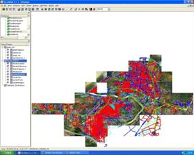
Figure 1 - Map of the city of Maraba Terraview imported into the software developed by INPE.
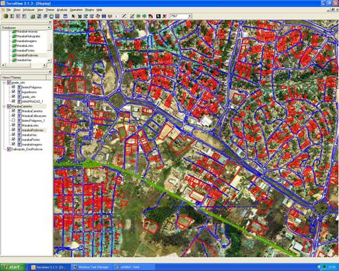
Figure 2 - Zoom in the map of Maraba - COSANPA.
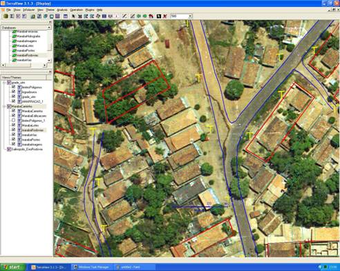
Figure 3 - Zoom in the map of Maraba - COSANPA.
CONCLUSION
Through the survey of the current situation of various operators sanitation both state and local, it appears that in most cases there is a register of networks in CAD system, with great difficulty by the same in the maintenance of connectivity between networks, and the interconnection between the networks technician registration with the records of consumers (commercial) on the map. There are some operators who use sanitation generic GIS software without specific application to the area of sanitation, which enable the simple association between a geographic element and a tabular data, not ensuring connectivity between sections of the network. Even in carriers with manual standardization of network design, as well as to have properly trained personnel for the registration of the network to maintain connectivity, non-conformities are found in the connections, since they require much attention from the user and is therefore subject to failure.
Some carriers have implemented GIS with network connectivity and connection with the trade register of consumers in pilot regions, but are currently difficult to implement the system in all units and municipalities, due to the high cost of licenses software. Some solutions to use with CAD software customization for the registration of networks in their units, which does not resolve definitively the question posed, often requiring the completion of various activities to obtain a simple consumer demand in a given node network.
The solution TerraLib using free software and its components already available, it is entirely feasible to implement, there are two cases in Brazil where it has already been successfully implemented.
The found this one year period of observation with various operators sanitation both state, and municipal, was that the main difficulty in reducing losses is allied to the operator's business processes. The reduction of water losses, both apparent and real, is the compartmentalization of the network, installation of macro-meters, replacement of water meters, network registration, registration of consumers linking the trade register with the consumer's location on the map and the same association , the network section, leak hunting actions, among others.
The GIS go through network and register for registering the location of consumers on the map. This should be considered carefully with respect to the costs of their realization. What was found is that with relative frequency, is hired to re-registration of consumers, without the request of supplying the same geographical location.
Another point to be considered is related to processes. It is suggested that initially the processes are changed and then made hiring data conversion, and may be cited as an example, the initial change of the registration process for a new connection before the closing of the Service Order, the contractor or employees own operator sanitation, conduct the registration of the extension and connection on the map, connected to commercial database to be closed following the order of service. This is an activity that is suggested to be daily, without the accumulation of services.
BIBLIOGRAPHY
TerraLib - Available in http://www. terralib. org. Accessed 03/15/2006.
Marco CASANOVA (PUC-Rio), Gilberto CAMERA (INPE), Clodoveu DAVIS (PUC Minas), Lúbia VINEYARDS (INPE), Gilberto Queiroz Ribeiro (INPE). Geographic Databases - Available in http://www. dpi. inpe. br/livros/bdados/ - Accessed 15/03/08.
CHASE, Donald V. Advanced Water Distribution Modeling and Management, University of Exeter, United Kingdom, 2004.
Pinheiro, Jose - Application Example TerraLib - Sao Paulo, Brazil, 2005.
