

Партнерка на США и Канаду по недвижимости, выплаты в крипто
- 30% recurring commission
- Выплаты в USDT
- Вывод каждую неделю
- Комиссия до 5 лет за каждого referral
Kristina’s Quick and Dirty Georeferencing Guide
For every georeferenced locality, you want to record the latitude, longitude, datum, extent, and errors, as well as the parameters that help a future researcher determine how you obtained that information (determination reference, latlong remarks, locality annotation, and named place.) The following is a quick guide of some of the first websites to check while georeferencing. It is imperative that before a georeferencer begins to georeference, one must read over and understand the georeferencing guidelines and error calculator manual.
1. US Localities
is your best bet for US localities, as it includes both Topo Quad and Terrain layers. Topo layers can be used for finding county and state boundaries. Coordinates are reported exactly and most data are in WGS84 datum. Acmemapper is http://mapper. /. If you are measuring road miles, then you should use Google Maps, available at http://maps. /. Google Maps does not have Topo maps, but you can measure along roads and it includes many extra features, such as street views and Google Maps Lab (which includes measuring tools, lat/long markers, etc).
Once you have searched for your locality and loaded the corresponding map on Acmemapper, you can choose the map type at the top right hand corner. You can zoom in or out using the zoom button on the top left. Extents and distances can be measured using markers. To place a marker, place the spot of interest in the center of the map, under the crosshairs, and click the mark button. To measure a distance for an extent or between two places, place another marker where you would like to measure distance. Then display the markers (button on bottom left of the search box) and you can see distances between markers.
This is an example of Acmemapper for Gilchrist, Oregon:
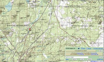
If you zoom to halfway on the zoom scale bar, you can see the black dotted lines representing county designations for the US. Gilchrist, OR is in Klamath County, next to Deschutes and Lake Counties. You can obtain coordinates by clicking on the marker. To set your coordinate and measuring preferences, such as for decimal degrees and kilometers, click the options button in the search box and make adjustments.
GEOREFERENCING CALCULATOR PARAMETERS (http://manisnet. org/gci2.html):
Coordinate Source: or Google Maps
Coordinate System: decimal degrees
Datum: Either WGS84
Coordinate Precision: exact
EXAMPLE:
Speclocality: Gilchrist, Oregon
DeterminationRef:
Coordinate Source: gazetteer
Coordinate System: decimal degrees
Datum: WGS84
Declat: 43.47722
DecLong: -121.68417
Named Place: Gilchrist
Extent: 0.7
MaxErrorDistance: 0.7
MaxErrorUnits: mi
2. Non-US Localities: Populated Places
I prefer to use for non-US localities, as one can obtain both coordinates and extents from the same website. uses NIMA data for coordinates, which are reported to the nearest minute and have a datum of WGS84. You could also use to locate the place and then use Acmemapper, paper maps or Google Maps to measure the extent and check the coordinates.
See an example of what a interface for Chocloca, Bolivia looks like here:
http://www. /world/BL/09/Chocloca. html
provides rough satellite-based maps and shows the placement of the coordinates on that map. If the town you are searching for is relatively small, then the point should show up without a yellow polygon underneath it. (Chocloca, Bolivia shows up as a single red point.) For such cases, you can determine the extent, by looking at distances to nearby towns as recorded underneath the satellite map, under the heading “Nearby Cities and Towns.” A copy of some of this section is located below.
West | North | East | South |
Tolomosita (6.2 nm) | Uleta (3.0 nm) Colon (3.4 nm) | Las Juntas (2.7 nm) |
For Chocloca, Bolivia, one can see that the closest town is Las Juntas, which is 2.7 nm (nautical miles) away. One can use this information to determine the extent of Chocloca by first converting 2.7 nautical miles into km. You can use the bottom of the error calculator or use Google by typing “2.7 nautical miles in km” into and press enter. For conversion, 2.7 nautical miles in km is 5.0004 km, and half of that distance, or 2.5 km, is the distance from Chocloca halfway to Las Juntas, which is used as the extent.
For towns with yellow polygons underneath the city name, such as Tokyo (http://www. /world/JA/40/Tokyo. html), you cannot use the Nearby Cities and Towns feature, as uses districts and areas within the city as the nearest features. For such larger cities, one must use another source to determine extent, such as searching Acmemapper or Google maps, or use a paper map at the Perry Castaneda Map Library collection, available at http://www. lib. utexas. edu/maps/
GEOREFERENCING CALCULATOR PARAMETERS for Falling Rain Coordinates (http://manisnet. org/gci2.html):
Coordinate Source: gazetteer
Coordinate System: degrees minutes seconds (note that even though the coordinates are reported both as decimal degrees and degrees minutes seconds, the original data from which obtained the coordinates is in degrees minutes)
Datum: WGS84
Coordinate Precision: nearest minute
EXAMPLE:
Speclocality: Chocloca, Tarija, Bolivia
DeterminationRef: Gazetteer
Datum: WGS84
Declat: -21.7167
DecLong: -64.7333
Named Place: Chocloca
Extent: 2.5
MaxErrorDistance: 5.026
MaxErrorUnits: km
OrigCoordSystem: degrees minutes seconds
LatLongRemarks: Extent is half the distance to Las Juntas, the next nearest named place, as reported by .
EXAMPLE:
Speclocality: Tokyo, Japan
DeterminationRef: and Acmemapper
Datum: WGS84
Declat: 35.6850
DecLong: 139.7514
Named Place: Tokyo, ppl
Extent: 19.5
MaxErrorDistance: 19.544
MaxErrorUnits: km
OrigCoordSystem: degrees minutes seconds
LatLongRemarks: Coordinates come from Fallingrain and extent is based on
Note that GIS programs are an option for non-US localities, as well, but their value depends on available GIS layers for the region of interest.
3. Non-US Localities: Localities that are not a Populated Place, such as Rivers or Mountains
This type of locality is one of the most time-consuming to georeference. It involves the use of a gazetteer, such as Acmemapper, Getty Thesaurus, Wikipedia’s GeoHack, Fallingrain or the NIMA website, to find a location and then map on Acmemapper or Google Maps. Electronic maps or paper maps can then be used to find the extent. If satellite imagery or online maps are bad, paper maps should be used. Scanned maps may be available at the Perry Castaneda Map Library collection or other such sources. Oftentimes such maps can be limited and/or of poor quality. Google Earth may be of some use, but its usefulness is diminished in places such as China or African deserts or areas with dense tree cover.
Rivers and streams anywhere must absolutely not be georeferenced using the coordinates available from any NIMA-based gazetteers (such as Fallingrain or even Biogeomancer), as these coordinates correspond to the mouths of the rivers and not the geographic center. Thus, rivers and streams must be wholly georeferenced on a map or satellite images of some kind.
Despite the ever-growing presence of online map collections and mapping websites, it is still rather difficult to obtain extents for many geographic features that are not widely known, such as small hills or lakes. If no large-scale paper maps are available to you for your region, then it might be possible to locate a map using the search tool on Google Images for possible maps. It is at this stage that a georeferencer becomes somewhat akin to a detective/research librarian/historian/geographer, and hopefully, after some unavoidable difficulty, extents will be procured.
. . .
In essence, this is where the fun starts. Good luck.
GEOREFERENCING CALCULATOR PARAMETERS (http://manisnet. org/gci2.html) if you used NIMA gazetteer or Fallingrain for coordinates:
Coordinate Source: gazetteer
Coordinate System: degrees minutes seconds (note that even though the coordinates are reported both as decimal degrees and degrees minutes seconds, the original data from which the websites obtained the coordinates is in degrees minutes seconds)
Datum: WGS84
Coordinate Precision: nearest minute
