
Партнерка на США и Канаду по недвижимости, выплаты в крипто
- 30% recurring commission
- Выплаты в USDT
- Вывод каждую неделю
- Комиссия до 5 лет за каждого referral
· Permeability is a measure of the ability of a rock or sediment to transmit water or other liquids.
· Water does not pass through impermeable materials.
· Geological processes, such as erosion, and human activities, such as waste disposal, can pollute water supplies.
· The three major regional watershed systems in Virginia lead to the Chesapeake Bay, the North Carolina Sounds, and the Gulf of Mexico.
· Interpret a simple groundwater diagram showing the zone of aeration, the zone of saturation, the water table, and an aquifer.
· Interpret a simple hydrologic cycle diagram, including evaporation, condensation, precipitation, and runoff.
· Locate the major watershed systems on a map (Chesapeake Bay, Gulf of Mexico, and North Carolina Sounds).
Important Words You Need to Know:
chemical weathering – when a rock's composition is altered and broken down by acids in the environment
deposition – the process by which products of erosion are laid down
erosion – the process by which Earth materials are carried away and are deposited by wind, water, gravity, or ice
ground water – water located underground in the zone of saturation
Karst topography – a landscape that develops from the action of groundwater in areas of easily soluble rocks characterized by caves, underground drainage, and sinkholes
permeability – the rate at which a fluid can move through a material
physical weathering – natural processes that takes big rocks and turn them into small rocks or sediments (rain, wind ice-wedging etc.)
sediments – particles of rock or organic materials that have been carried along and deposited by water, wind, or glaciers; small pieces of rock, shell, and other material that are broken down by the processes of weathering
sinkhole – funnel-shaped depressions that result from the dissolution of limestone along cracks and
watershed – all of the land or area that drains into a specific river system
water table – the upper surface of a zone of saturation
weathering – breaking down of rocks and other material at the Earth’s surface
zone of aeration – the underground region where the pores are filled mostly with air
zone of saturation – the underground region where all of the pores are filled with water
Now You Try It!
Practice Questions: Circle the correct answer!
1. The photograph below shows an eroded plateau found in the southwestern United States.
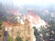
The landscape was developed by the processes of–
A crustal uplift and stream erosion
B crustal folding and stream erosion
C crustal uplift and glacial erosion
D crustal folding and glacial erosion
2. Which of the following Virginia provinces has the most karst topography?
AX Coastal Plain
B Blue ridge
C Piedmont
D Valley and Ridge
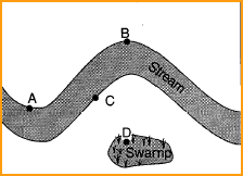
3. The map below shows the area surrounding a meandering stream. At which point is erosion greatest?
A Point A
B Point B
C Point C
D Point D
4. The cross section below shows sedimentary rocks being eroded by water at a waterfall.
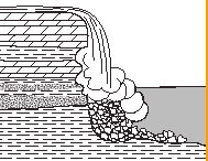
The sedimentary rock layers are being weathered and eroded at different rates primarily because the rock layers -
A formed during different time periods
B contain different fossils
C have different compositions
D are horizontal
5. The diagram below shows a glacial landscape. Which evidence suggests that ice created this landscape?
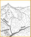
A U-shaped valleys
B many stream valleys
C sorted sediment on the valley floor
D the landslide near the valley floor
6. The diagram below shows granite bedrock with cracks. Water has seeped into the cracks and frozen. The arrows represent the directions in which the cracks have widened due to weathering.
Which statement best describes the physical weathering shown by the diagram?
A Enlargement of the cracks occurs because water expands when it freezes.
B This type of weathering occurs only in bedrock composed of granite.
C The cracks become wider because of chemical reactions between water and the rock.
D This type of weathering is common in regions of primarily warm and humid climates.
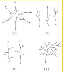
7. Which stream-drainage pattern most likely developed on the surface of a newly formed volcanic mountain?
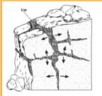
8. This huge hole is in Florida. It occurred when the surface suddenly collapsed because the land beneath it was being secretly eroded by groundwater. What do we call this?
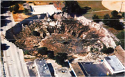
A crater
B sinkhole
C karsthole
D pothole
Earth Science SOL Review Sheet #9 : Plate Tectonics
Essential Knowledge and Skills
· Earth consists of a solid, mostly iron inner core; a liquid, mostly iron outer core; a rocky, plastic mantle; and a rocky, brittle crust.
· Relative plate motions and plate boundaries are convergent (subduction and continental collision), divergent (sea-floor spreading), or transform.
· Ocean crust is relatively thin, young, and dense.
· Continental crust is relatively thick, old, and less dense.
· Continental drift is a consequence of plate tectonics.
· Hot spot volcanic activity, such as volcanic islands, is exceptional in that it is not related to plate boundaries.
· Earthquake activity is associated with all plate boundaries.
· Major features of convergent boundaries include collision zones (folded and thrust-faulted mountains) and subduction zones (volcanoes and trenches).
· Major features of divergent boundaries include mid-ocean ridges, rift valleys, and fissure volcanoes.
· Major features of transform boundaries include strike-slip faults.
· A fault is a break or crack in Earth’s crust along which movement has occurred.
· Most active faults are located at or near plate boundaries. Earthquakes result when movement occurs along a fault.
· When rocks are compressed horizontally, their layers may be deformed into wave-like forms called folds. This commonly occurs during continental collisions.
· A volcano is an opening where magma is erupted onto Earth’s surface. Most volcanic activity is associated with subduction, rifting or sea-floor spreading.
Important Words You Need to Know:
converging or convergent boundary – a boundary that forms when two lithospheric plates come together, or converge (collide)
crust – thin, outermost layer of the Earth
divergent boundary – also called a spreading center; where two adjacent plates are moving away from each other
earthquakes – vibrations caused by the sudden movement of Earth’s crust
fault – a break or crack in Earth's crust along which movement has occurred
fault-block mountains – mountains formed from blocks of crust that have been faulted and tilted at the same time
fold – bend in rock with an anticline (up-fold) and syncline (down-fold)
inner core – solid, innermost center of the Earth
lithosphere – outer solid shell of Earth that extends to a depth of about 100 kilometers
mantle – layer of the Earth that extends from the bottom of the crust to the outer core
mid-ocean ridge – undersea mountain chain where new ocean floor is produced; a constructive (divergent) plate boundary
outer core – layer of the Earth surrounding the inner core; liquid iron and nickel
plate tectonics – theory of the formation and movement of the rigid pieces, or plates, that cover Earth's surface explains movements of continents and changes in Earth’s crust caused by internal forces
sea floor spreading – the production of new ocean crust along a mid-ocean ridge/rift system that moves older seafloor away from the ridge enlarging the ocean basin and separating continents
subduction – process in which crust plunges back into Earth’s interior
volcano – an opening in Earth's crust through which an eruption takes place
Now You Try It!
Practice Questions: Circle the correct answer!
1. Which sample best shows the physical properties normally associated with rocks found at a convergent boundary?
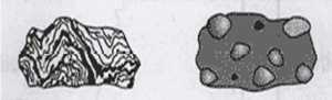
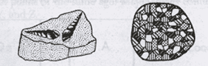 A C
A C
B D
2. The Rocky Mountains have been created by which type of boundary?
AX Convergent
B Divergent
C Spreading center
D Transform
3. In which diagram do the arrows best represent the motions of Earth’s crust at an ocean trench?
|
|
|
|
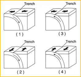

|
Из за большого объема этот материал размещен на нескольких страницах:
1 2 3 4 5 6 7 |
