

Партнерка на США и Канаду по недвижимости, выплаты в крипто
- 30% recurring commission
- Выплаты в USDT
- Вывод каждую неделю
- Комиссия до 5 лет за каждого referral
· fire management zones, which establish our long-term balanced fire regime on public land by defining objectives for fuel management across the landscape
· major fuel breaks, which are permanent, slashed fuel breaks of between 20–40 m and include or adjoin a mineral earth vehicle track.
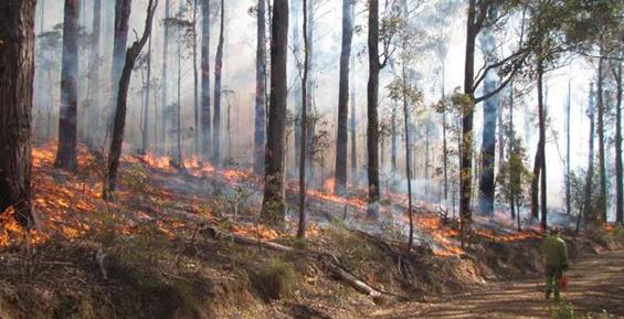
The main fuel management action is planned burning, which is deliberate burning to reduce the quantity of leaf litter, twigs, bark and undergrowth. It is the most effective method of managing fuel on large areas of public land, and the main way we reduce bushfire risk. Fuel management also serves ecosystem resilience purposes, such as regeneration of plant species and habitat. Where appropriate, we may also manage fuel by slashing, mowing, mulching and applying herbicide. We will work with industry groups and communities to investigate other fuel management techniques.
To develop our fuel management strategy, we combined our knowledge of bushfire behaviour and PHOENIX RapidFire simulations with our prioritisation of human life communities, infrastructure and public administration facilities, and of economic, environmental and cultural heritage and social assets.
Reducing bushfire residual risk
Residual risk is the risk, on average and across the whole landscape—including public and private land—that bushfires will impact on life, property or other assets. It is expressed as the percentage of the risk that remains after bushfire history and fuel management (mainly planned burning) activities are taken into account. For example, 80% residual risk means that the risk of property and infrastructure being impacted by a bushfire—on average, throughout the landscape—is 20% less than it would have been had we never had bushfires and fuel management to reduce the fuel hazard. The complex mosaic of fuel-reduced and bushfire-burnt patches across the landscape—with different times since the last fire—is mainly what determines residual risk at any point in time. Residual risk changes constantly as bushfires burn new areas, as we manage fuel, and as fuel accumulates.
One way DELWP measures the effectiveness of the fuel management strategy is by how well it reduces residual risk. PHOENIX RapidFire allows us to simulate the reduction in residual risk at any particular location, at a particular point of time, if we reduce fuel hazard at the ignition points and along the spread paths of bushfires that could impact on it. Then we prioritise planned burning in areas which result in the greatest risk reduction.
Annual fuel management activities will be guided by a long-term residual risk target.
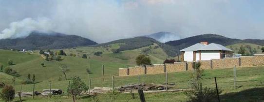
Picture caption: Planned burning in the Tambo district © Greg McCarthy DELWP
The fuel management strategy aims to ensure that:
· through to 2050, as fuel re-accumulates in forests burnt in 2002–03 and 2006–07, residual risk to life and property does not return to pre–2006 levels, but is kept below 65%
· through to 2050, residual risk to life and property continues to decline.
Map 5: Fuel management strategy (western side of landscape)
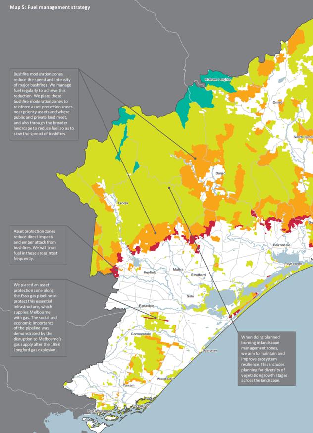
Information relating to areas to north-west of Dargo and south-east of Licola
Bushfire moderation zones reduce the speed and intensity of major bushfires. We manage fuel regularly to achieve this reduction. We place these bushfire moderation zones to reinforce asset protection zones near priority assets and where public and private land meet, and also through the broader landscape to reduce fuel so as to slow the spread of bushfires.
When doing planned burning in landscape management zones, we aim to maintain and improve ecosystem resilience. This includes planning for diversity of vegetation growth stages across the landscape.
Information relating to west of Heyfield
Asset protection zones reduce direct impacts and ember attack from bushfires. We will treat fuel in these areas most frequently.
Information relating to south of Rosedale
We placed an asset protection zone along the Esso gas pipeline to protect this essential infrastructure, which supplies Melbourne with gas. The social and economic importance of the pipeline was demonstrated by the disruption to Melbourne’s gas supply after the 1998 Longford gas explosion.
Information relating to west and south-west of Bonang
North-south corridors of bushfire moderation zones break up the landscape, helping us to suppress bushfires and minimise large, landscape-scale bushfires. We have placed more bushfire moderation zones in key bushfire catchments, to reduce the risk of frequent or high-consequence bushfires.
Information relating to west of Bonang and north of Buchan
Our planned burning in landscape management zones will help protect the habitat of priority animal species that live in small, isolated populations.
Information relating to north and east of Cann River
We will increase planned burning in these areas, to reduce risk to communities and the tourism industry.
Information relating to north-west of Lakes Entrance
We have extended the planned burning frequency in bushfire moderation zones in this area from eight to 10 years, to protect a priority plant species. Our simulations show his change has not significantly increased residual risk in the landscape.
Map 5: Fuel management strategy (western side of landscape)
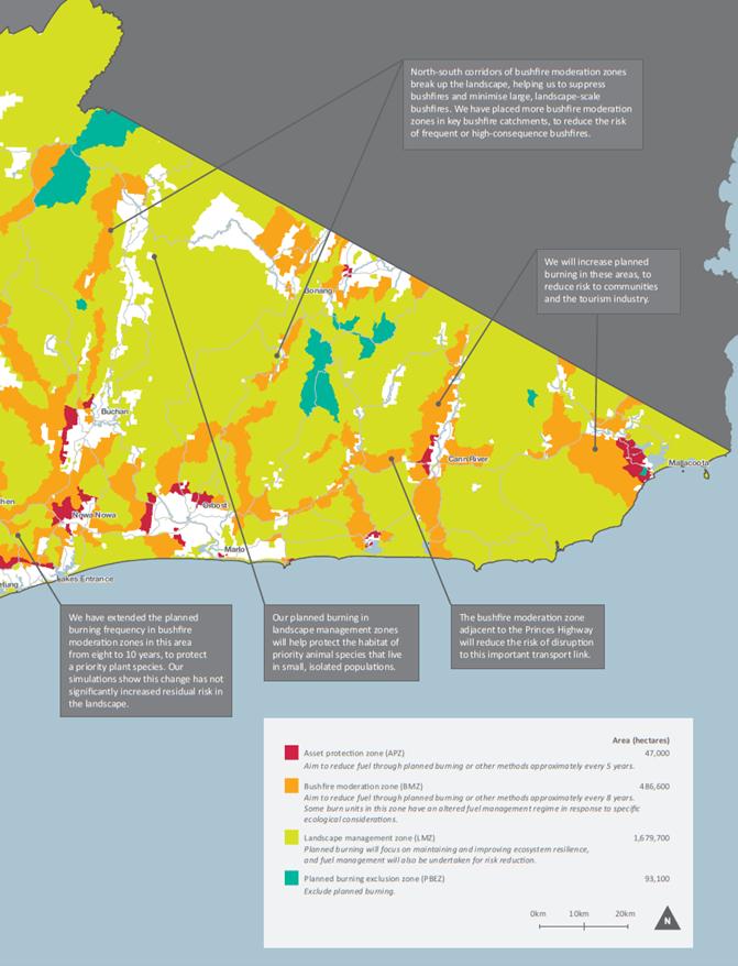
Figure 1 shows measured and expected residual risk in our landscape from 1980 through to 2050. It shows residual risk (the blue line and shaded darker blue area):
· fell sharply in response to major bushfires in the early 1980s
· increased in the following years as vegetation slowly grew back, from around 44% in 1984 to almost 78% in 2002
· decreased to 42% in 2010 – a historic low – as a result of major bushfires in 2003 and 2006 and planned burning
· increased as fuel re-accumulated in the bushfire-affected areas
· will be maintained below levels that existed before the 2003 and 2006 bushfires, by managing fuel on public land.
The figure shows (the darker blue shaded area) that implementing our fuel management strategy on public land will reduce residual risk to between 33% and 69%. Implementing our strategy should see risk decline well below current levels, towards the lower end of the indicated range.
The exact residual risk in future will depend on where we schedule our planned burns each year within the zones; the size, intensity and location of bushfires when they occur; and how quickly fuel re-accumulates in burnt areas. We have
forecast the future residual risk using PHOENIX RapidFire bushfire simulation software and multiple planned burning scenarios. The uncertainty of all the factors that influence residual risk reduces our ability to pinpoint exactly what residual risk will be in the future.
Figure 1 also shows (the green dotted line) that fuel management on private land could theoretically reduce residual risk by up to an additional 7%, which highlights the importance of complementary bushfire preparation, preparedness, response and recovery actions. DELWP will support other agencies (mainly CFA and local governments) and landowners to prioritise and focus their fuel management activities on the highest-priority areas of private land. Local governments can also use our information and products when developing their own strategies for managing risk on private land.
Figure 1: Residual risk 1980–2050
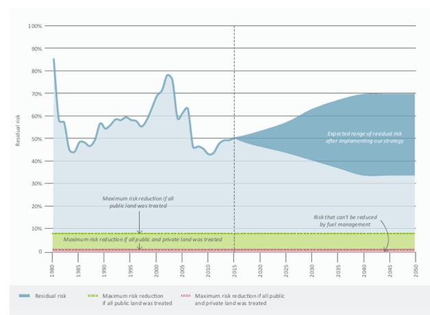
Note: The expected range and theoretical maximum levels of risk reduction to human life and property shown in this figure were simulated under a weather scenario of a Forest Fire Danger Index of 130.
Picture caption: Planned burning in the Snowy district © Michael Beckers DELWP
Fire management zones
Fire management zones (FMZs) define objectives for fuel management across the landscape. FMZs were first established in Victoria in 1995 and outline how frequently to treat areas. We will review and adjust FMZs occasionally, as new technology, science and information become available. This plan incorporates the outcomes of a review of our landscape’s FMZs.
There are four types of FMZs. They are:
· Asset Protection Zone: an area around properties and infrastructure where we do intensive fuel management to provide localised protection, to reduce radiant heat and ember attack on life and property in the event of a bushfire
· Bushfire Moderation Zone: an area where we manage fuel hazard to reduce the speed and intensity of bushfires, and to protect nearby assets, particularly from ember attack in the event of a bushfire
· Landscape Management Zone: an area where we manage fuel to reduce residual risk, improve ecosystem resilience, and for other purposes (such as to regenerate forests and protect water catchments)
· Planned Burning Exclusion Zone: an area where we try to avoid planned burning, mainly because the vegetation cannot tolerate fire.
Map 5 shows the location of FMZs in our landscape. In:
· asset protection zones, we aim to reduce fuel by planned burning or other methods about every five years, over a total 47 000 ha
· bushfire moderation zones, we aim to reduce fuel about every eight years, over a total 486 600 ha; we will alter the fuel management regime in some burn units in this zone to meet ecological objectives
· landscape management zones, we will do planned burning mainly to maintain and improve ecosystem resilience, but also to reduce fuel, over a total 1 679 700 ha.
Fire operations planning
Each year we produce an updated fire operations plan for each region in our landscape. These plans:

|
Из за большого объема этот материал размещен на нескольких страницах:
1 2 3 4 5 6 |
