

Партнерка на США и Канаду по недвижимости, выплаты в крипто
- 30% recurring commission
- Выплаты в USDT
- Вывод каждую неделю
- Комиссия до 5 лет за каждого referral
Strategic bushfire management plan
Alpine and Greater Gippsland
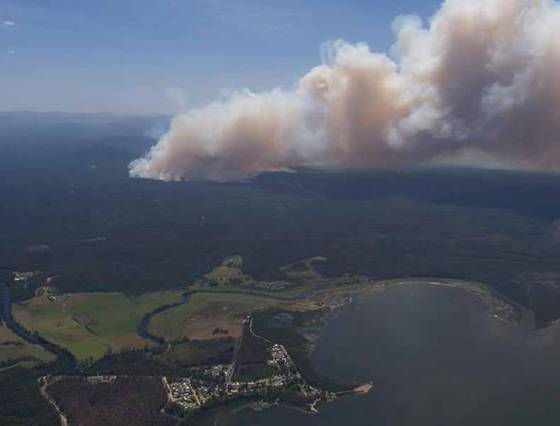
Picture caption: A bushfire, with Bemm River in the foreground © Michael Beckers DELWP

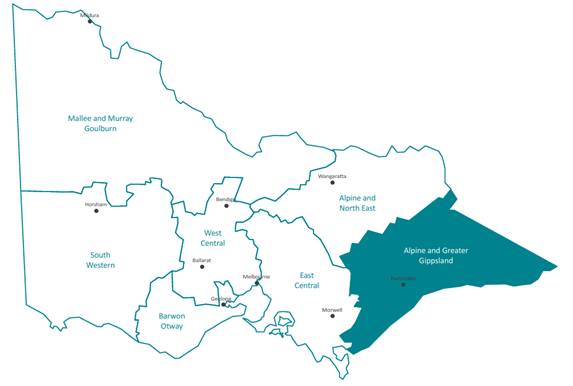
Picture caption: Map of Victoria showing the state's seven bushfire risk landscapes and the main population centre in each
© The State of Victoria Department of Environment, Land, Water and Planning 2015
![]()
This work is licensed under a Creative Commons Attribution 4.0 International licence. You are free to re-use the work under that licence, on the condition that you credit the State of Victoria as author. The licence does not apply to any images, photographs or branding, including the Victorian Coat of Arms, the Victorian Government logo and the Department of Environment, Land, Water and Planning (DELWP) logo. To view a copy of this licence, visit http://creativecommons. org/licenses/by/4.0/
Printed by Impact Digital, Brunswick.
ISBN 978-1-74146-700-0 (print)
ISBN 978-1-74146-701-7 (pdf)
Disclaimer
This publication may be of assistance to you but the State of Victoria and its employees do not guarantee that the publication is without flaw of any kind or is wholly appropriate for your particular purposes and therefore disclaims all liability for any error, loss or other consequence which may arise from you relying on any information in this publication.
Contents
Introduction.. 4
About bushfire in our landscape. 7
What this plan prioritises for protection.. 12
How do we decide what to prioritise for protection?. 12
Communities. 17
Infrastructure. 18
Public administration facilities. 19
Environment 20
Economy. 21
Cultural heritage and social assets. 21
How we will protect our landscape. 22
Our fuel management strategy. 22
About our fuel management strategy. 22
Reducing bushfire residual risk. 23
Fire management zones. 29
Fire operations planning. 29
Balancing our fuel management approach. 30
Other bushfire management strategies. 36
Preventing bushfires. 36
Being prepared for bushfires. 36
Responding to bushfires. 37
Recovering after bushfires. 37
How we will continuously improve the planning process. 38
Glossary. 40
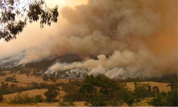
Picture caption: 2002–03 Alpine fire in the Deddick area © Michael Beckers DELWP
Introduction
Victoria is one of the most fire-prone areas in the world. In past decades, we have seen the disastrous effects that bushfires can have on communities — on people, properties, our economy and the environment.
Under the Forests Act 1958, and in line with the Code of Practice for Bushfire Management on Public Land 2012, the Department of Environment, Land, Water and Planning (DELWP) is responsible for managing bushfire risk on public land. The code of practice’s two objectives are to:
· minimise the impact of major bushfires on human life, communities, essential and community infrastructure, industries, the economy and the environment: human life will be afforded priority over all other considerations
· maintain or improve the resilience of natural ecosystems and their ability to deliver services such as biodiversity, water, carbon storage and forest products.
The code of practice requires DELWP to undertake strategic bushfire management planning. This is the first strategic bushfire management plan for the Alpine and Greater Gippsland bushfire risk landscape, one of Victoria’s seven bushfire risk landscapes. The strategic planning approach we used to develop this plan replaces our previous fire protection planning approach.
We developed this plan in the context of Victoria’s new emergency management arrangements. The Victorian Government’s Emergency Management Reform White Paper and subsequent legislation aim to build community resilience through increased participation and shared responsibility.
This plan explains the fuel management strategy that we—DELWP and Parks Victoria (PV)—will undertake to minimise the impact of major bushfires on people, property, infrastructure, economic activity and the environment, to achieve the two code of practice objectives. It explains how we will do this by placing fire management zones—asset protection zones, bushfire moderation zones, landscape management zones and planned burning exclusion zones—on public land, and by doing other fuel management activities.
History tells us a small number of major bushfires have caused the greatest losses of human life, although any bushfire has the potential to result in loss of life and property. In some cases, major bushfires have also damaged fire-sensitive ecosystems and species.
As well as fuel management, the code of practice emphasises reducing bushfire risk through other strategies and actions for:
· prevention, to minimise the occurrence of bushfires, particularly those started by people
· preparation, so we are adequately prepared for bushfires and can better respond to them when they occur
· response, to ensure a timely and adequately resourced initial attack on all detected bushfires on public land
· recovery, to ensure we identify risks and damage resulting from bushfires.
Over the next few years, with community and stakeholder engagement, we will refine and document risk-based strategies for bushfire prevention, preparedness, response and recovery.
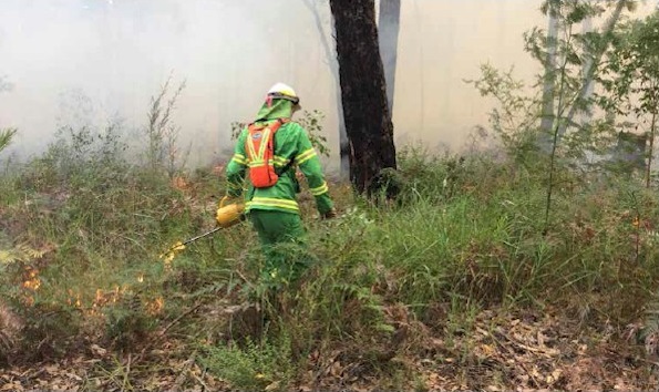
Picture caption: Planned burning ignition © DELWP
We use a risk-based approach to planning for bushfire management, based on the International Standard for Risk Management ISO 31000. Our approach:
· pairs local knowledge with world-leading bushfire simulation software, historical data and the best-available science to understand how bushfires behave
· incorporates multiple weather patterns and ignition likelihood weightings
· incorporates the views of communities, industries and other stakeholders about what they value and want to protect from bushfires
· proposes ongoing monitoring, evaluation and reporting about how implementation of our planning approach is reducing bushfire risk.
The international standard for risk management, with which our strategic planning approach complies, reflects the fact that risk can never be completely eliminated. Bushfires will still occur, and everyone needs to be prepared and ready to respond. But bushfire risk can be reduced with a high-quality risk management approach.
Our planning is based on partnerships. DELWP and PV have partnered with communities and other fire and emergency services agencies to develop this plan. It relies on action by governments, businesses and households, on public and private land, to make communities and the things we value safer. We will continue to work in partnership with communities, stakeholders and other agencies to implement this plan.
We thank everyone who is contributing to our planning approach, particularly the members of the Alpine and Greater Gippsland bushfire risk landscape’s Internal Working Group and Landscape Reference Group. We also acknowledge the contributions of staff and representatives of DELWP, PV, VicForests, Country Fire Authority (CFA), the East Gippsland and Wellington shires, private land managers and communities in our landscape. We will continue to work in partnership with the agencies and organisations above, and with all other interested parties, to reduce bushfire risk on public and private land. We will also encourage residents and land owners to find out about bushfire risk on their property and have up-to-date bushfire plans.
We welcome this strategic, risk-based approach. As the officers responsible for ensuring DELWP’s compliance with the code of practice, and for effective strategic planning and implementation at the regional level, we consider it will result in better bushfire risk management, safer communities and property, stronger local economies and more resilient ecosystems.
This document is a summary of our planning approach, and there is much information that sits behind it. To find out more, including how you can be involved in reviews and updates of the plan, visit www. delwp. vic. gov. au.
Alan Goodwin, DELWP Chief Fire Officer
Michael Timpano, DELWP Regional Director, Gippsland
Picture caption: Planned burning with an aerial driptorch © DELWP
About bushfire in our landscape
For strategic bushfire management planning purposes, DELWP and PV divide Victoria into seven bushfire risk landscapes. These are areas where bushfire behaviour—including the types of places that bushfires start, the terrain and vegetation through which they spread, and the types of impact they have—is sufficiently common to plan for the area as a whole.
Map 1 shows the Alpine and Greater Gippsland bushfire risk landscape. It is 3 290 000 ha, or 14% of the state’s area. Of the landscape, 70% is public land and 30% is private land.
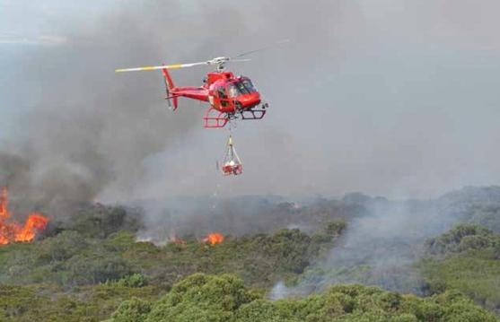
Managing bushfire risk is essential. In our landscape, the 1926 Black Sunday bushfires killed 61 people and destroyed farms, homes and forests. Since 2000, over 1.4 million ha of the landscape has been burned by bushfires. In the last 10 bushfire seasons, DELWP responded to an average 136 bushfires a year in our landscape. We suppressed about 75% of these bushfires before they grew to 5 ha. Rapidly detecting and suppressing bushfires before they grow to a size and intensity that makes them difficult to control is a core part of our approach to managing bushfire risk.

|
Из за большого объема этот материал размещен на нескольких страницах:
1 2 3 4 5 6 |
